
Last modified: 2008-07-05 by dov gutterman
Keywords: neretva | dubrovacko-neretvanska | drijeva | narent |
Links: FOTW homepage |
search |
disclaimer and copyright |
write us |
mirrors
See also:
One of the oldest historical source for flag examination is
map. In monography of Historical Institute in Belgrade
"Monumenta Cartographica Jugoslaviae II" Narodna
knjiga, Belgrade 1979. author Gordana Tomovic compares different
XVIth century naval maps of Balkan peninsula. She notices flags
above some place names on map preserved in 'Bibliotheque National
in Paris (Departement des cartes et plans)' made on pergament by
Angelino Dulcert (1339a.d.):
"14. Flag above town of Neretva (Drijeva, Narent) - in
today's Croatia. Colours are not mentioned. This one is possibly
predecessor of today's flag of town of Metkovic,
and Dubrovacko-Neretvanska County in
Croatia. If it is - then the fields are blue and white."
Ivan Sarajcic, 2 May 2000
I haven't found yet any direct connection between the 14th
century flag and the newly designed flag of Metkovic, but I tried
to figure out what Drijeva is. It is not to be found in the
ordinary lexicons where I loked, but there is mention of it in
the encyclopedia (Hrvatska Enciklopedija, book 3, Zagreb 2001):
"Drijeva, medieval market town on lower Neretva, today the
settlement Gabela. Name was given according to the Old Slavic
word for ship ('drijevo'), and in the sources in Latin is called
'portum Narenti' and 'forum' or 'mercatum Narenti' . Drijeva were
developed as merchant center though which the trade between the
coast and the inland was performed. The trade was done with
different staff, mostly corn, salt and even slaves from Bosnia.
It is first mentioned 1186 in a contract between Serbian ruler
Stefan Nemanja and Dubrovnik, in which the freedom of trade to
Dubrovnik merchantmen was guarantied in Drijeva. In 13th century
Drijeva shared the fate of Zahumlje, and around 1280 were under
the rule of George, sin of the duke Andrija. At the beginning of
the 14th century were under the Serb rule, and in 1303 the
Dubrovnik is mentioned as having leased the Drijeva customs
facilities. They were paying to the rulers yearly fee of 6000
golden coins (1356). Since 1326 til 1382 when they are under the
rule of the Croato-Hungarian king Lui (Ljudevit) I Anjou. Since
1404 are part of fief of the duke Hrvoje Vukcic Hrvatinic, and
since 1410 of the duke Sandalj Hranic, and since 1435 of the duke
and the herzog Stjepan Vukcic Kosaca, and in 1444 temporarily in
hands of the Bosnian king Stjepan Tomas. The duke Sandalj shared
the levies from Drijeva with the Radivojevics (Vlatkovics) and
Pavlovics, but the herzog Stjepan took it all for himself. In
1448 the Osmanian troops burned Drijeva down, and in 1452 the
Venetians rised a new settlement on the right bank of Neretva.
After the herzog's death in 1466 Drijeva are living through hard
days and at most at 1493 they were taken by Turks who set there
their emin to collect the customs taxes."
Then we need to look at the entry for Gabela (Hravtska
enciklopedija, book 4, 2002): "Gabela (Ital.
gabella:customs, from Arab. al-qabala: tax), medieval marketplace
Drijeva, later are named as Gabela, fince the second half of 15th
century. At least in 1493 it is conquered by Turks. Before 1558
they built a rectangular fort with towers at angles, named
Sedislam (the Wall of Islam). It became the center of the Gabela
captany (orignized before 1561). Since 1537 Gabela is part of
Nevesinje kadiluk. In the middle of 17th century Ali-pasha Cengic
rebuilt and reinforced the fort (so called Novi grad). In 1693
the Venetians captured Gabela and repaired the fort, and in 1715
they destroyed it. Since 1718 Gabela is again under the Osmanli
rule. Until 1878 it was an important place the the border between
Herzegovina and Dalmatia, but the role of Gabela as the fort was
take by the town of Pocitelj."
Gabela is today a small town in Capljina community in B&H
about 3 km from the border with Croatia on the right bank of the
Neretva river, again an important point of transit, with a rail
road passing though it. It may be interesting to note that based
on the archeological founds and his analysis of Homer's work a
Mexican archeologist R. S. Prais (sp?) determined that this may
be the site of the ancient city of Troy.
The connection between Narent/Drijeva/Gabela, now in B&H and
Metkovic is not quite unusual - there is about 4 km from center
to center even if the border passes in between.
Željko Heimer, 14 Febuary 2004

The flag from the map of Angelino Dulcert
image by Tomislav Todorovic, 10 November 2006
The flag from the Catalan Atlas
image by Tomislav Todorovic, 10 November 2006
The flag from the facsimile of the Catalan Atlas
image by Tomislav Todorovic, 10 November 2006
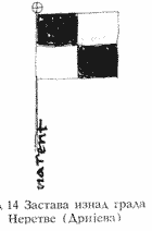
The flag from the map of Angelino Dulcert
The flag of Neretva from the map of Angelino Dulcert is quartered
blue and white, as described in "Libro del conoscimiento de
los reinos" [1]. According to Aleksandar Solovjev,
"Contributions to Bosnian and Illyrian heraldry" [2],
at the time of writing of this book (about 1330), Neretva was the
part of Bosnia (since 1324), whose coat of arms at that time was:
azure a bend argent; that is its oldest known coat of arms, used
by ban Stjepan Kotromanic' (died 1353) [3]. The flag attributed
to Neretva thus might actually be the flag of Bosnia, having been
derived from its coat of arms.
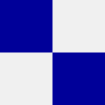
The flag from the Catalan Atlas
In the Catalan Atlas, the flag of Neretva is quartered blue and
silver; the silver is darkened by age so much that is is almost
black nowadays (on the above image, the shade of silver is shown
according to the recommendations of International
Association of Amateur Heralds). This could have been seen at
the site of the National Library of France, but the pages about
the Catalan Atlas, which had contained the scans of complete map,
are no longer available online. The photos currently available is
at <www.brown.edu>.
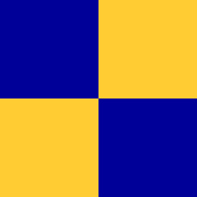
The flag from the facsimile of the Catalan Atlas
British Museum, London, possesses a facsimile of the Catalan
Atlas, in which the flag of Neretva is painted with gold instead
of silver , the error which has appeared there at some other
flags as well [4]. The photos available are at <www.brown.edu>,
<turkeyinmaps.com>
and <www.georgeglazer.com>.
Sources:
[1] Wigal, Donald: Historic maritime maps used for historic
exploration 1290-1699 Parkstone Press, New York, USA, 2000 ISBN
1-85995-750-1
[2] Solovjev, Aleksandar: Prinosi za bosansku i ilirsku
heraldiku. Istorija srpskog grba i drugi heraldic<ki radovi
Pravni fakultet Univerziteta u Beogradu: Dosije; Belgrade, 2000
ISBN 86-80763-90-X
[3] D. Spasic', A. Palavestra and D. Mrdjenovic': Rodoslovne
tablice i grbovi srpskih dinastija i vlastele Beograd: Bata, 1992
[4] Istorija otkric'a i istraz<ivanja, vol. I: Poc<etak
istraz<ivanja Mladinska knjiga, Ljubljana, 1979. Original
title: A History of Discovery and Exploration, vol. I: The Search
Begins,1973, Aldus Books Limited, London.
Tomislav Todorovic, 10 November 2006
Flags at Libro del conoscimiento de los reinos

The flag from Manuscript II
image by Tomislav Todorovic, 3 December 2006
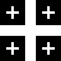
The flag from Manuscript III
image by Tomislav Todorovic, 3 December 2006
In all three manuscripts of "Libro del conoscimiento de
los reinos" which are kept in the libraries in Madrid, the
flag of Neretva is described as quartered blue and white, but is
depicted as such only in Manuscript I. In Manuscript II, the same
text is accompanied with the image of a blue flag, charged with a
cross cantonned with four crosslets, all in white. In Manuscript
III, the flag of Neretva is black with white cross and crosslets
[1]. Both images above are the reconstructions based on the
descriptions from this source.
According to Croatian historian Josip Smodlaka, this might have
been the flag of Stjepan Vukc<ic' Kosa<a, the Duke of St
Sava (Serbo-Croat: Herceg od Sv. Save), from whose title the name
of Herzegovina was derived: the paternal coat of arms of Queen
Katarina of Bosnia, daughter of Duke Stjepan and widow of King
Stjepan Tomas<, which is shown on her tomb in Rome, bears
three bends and overall an escutcheon charged with a cross
(quoted after [1]). According to Aleksandar Solovjev [2], that
escutcheon might have symbolized either the title of Duke Stjepan
or the fact that Queen Katarina was descended through female line
from Prince Lazar Hrebeljanovic' of Serbia - in both cases,
Serbian connections of this emblem. The flag might indeed be
somehow derived from the armorial achievement od Duke Stjepan,
because his crest is a demi-lion bearing a flag with two
crosslets in pale [3, 4]. Lastly, the Armorial of Charolais,
compiled in 1425, shows the following blazon as the coat of arms
attributed to Serbia: purpure a cross between four crosslets Or
[3]. The original of this armorial is lost (only a copy from 1656
exists, which is kept in Brussels), so the real origins of this
coat of arms would be difficult to trace, but still it seems to
show the same connections mentioned above. Bearing in mind that
the three above-mentioned manuscripts of "Libro del
conoscimiento de los reinos" were written in late XV
century, when all these armorial bearings were well known, the
final conclusion might be that the flag with cross and crosslets
attributed to Neretva might actually have been the flag of
Herzegovina.
The image of the coat of arms of the Kosa<a family can be seen
at <www.srpskapolitika.com>,
and the flag held by the demi-lion in the crest was the
basis of the design of the flag of Bilec'a,
Bosnia and Herzegovina.
Sources:
[1] Solovjev, Aleksandar: Zemlje Juz<nih Slovena i njihovi
grbovi u s<panskom putopisu XIV veka. Istorija srpskog grba i
drugi heraldic<ki radovi Pravni fakultet Univerziteta u
Beogradu: Dosije; Belgrade, 2000 ISBN 86-80763-90-X
[2] Solovjev, Aleksandar: Prinosi za bosansku i ilirsku
heraldiku. (Ibid.)
[3] Palavestra, Aleksandar: Comments. (Ibid.)
[4] D. Spasic', A. Palavestra and D. Mrdjenovic': Rodoslovne
tablice i grbovi srpskih dinastija i vlastele Beograd: Bata,
1992.
Tomislav Todorovic, 3 December 2006
The 35th flag mentioned and illustrated in the "Book of
All Kingdoms" [e9s50] is
apparently attributed to "Narent", a city: The author
reports he sailed from "Boxina" and then visited the
cities "Sara", "Simbichon" and
"Narent" and then dewscribed the flag of
"this" land, being unclear if only "Narent"
is meant or also the other two cities.
This as depicted in the 2005 spanish illustrated transcription [e9s05], a quarted flag, white over
purple, in the ogival default shape of this source.
The anonymous author of [e9s50]
describes the flag thusly (my translation, A.M): "And the
king of this land has for sign a quartered pendon, the two
quarters purple and the two white like these."
António Martins-Tuválkin, 18 November 2007
Sara would be modern city of Zadar
(in Italian: Zara), the pre-Roman Jadera. Simbichon would be
modern-days Šibenik while Narent
would be modern-days Metkovic' more
or less, at least this is the city that considers itself the
inheritor of the medieval port of Narent taht was located a bit
further upstream the river Neretva (Italian Narenta).
The mdoern city of Metkovic' adopted
the Coat of Arms in 1990's that reflect this ancient design and
bears it on its flag.
Željko Heimer, 19 November 2007
Flag on the map of Guillelmus Soleri
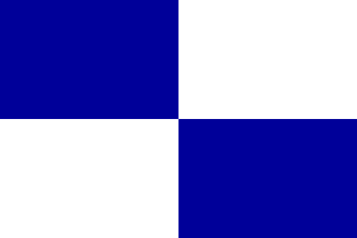
image by Tomislav Todorovic, 24 July 2007
The flag of Neretva on the map of Guillelmus Soleri, which was
created on Majorca c. 1385, and nowadays is kept in National
Library of France, Paris, is very similar to that from the map of
Angelino Dulcert, only has a more oblong form.
Source: Wigal, Donald: Historic maritime maps used for
historic exploration 1290-1699 Parkstone Press, New York, USA,
2000 ISBN 1-85995-750-1.
Tomislav Todorovic, 24 July 2007