
Last modified: 2008-12-26 by phil nelson
Keywords: weather flags |
Links: FOTW homepage |
search |
disclaimer and copyright |
write us |
mirrors
See also:
The WMO (World Meteorological Organization) shows a number of flags an pennants in Annex II. National Systems of Visual Storm Warning Signals (Day Signals).
Chapter 8, part of Vol. D `Information for Shipping', one of WMO's operational documents. The introduction to this Chapter states:
As stipulated in the International Convention for the Safety of Life at Sea (…), Countries concerned should display at coastal points appropriate visual storm warning signals when applicable.
WMO Technical Regulations specifies that any Member establishing a new visual storm warning signal system should adopt the international system.
This part contains information on the systems of visual storm warning systems adopted by the various maritime countries. Where no such signals are used, a statement to this effect is given.
Annex I shows the International System of Visual Storm Warning Signals: black flags describing wind force (bottom of page) which may be however of another colour, if suitable.
There is also a breakdown of signals by country.
This very interesting table mentions countries with or without (official) warning system.
To give a few examples: Egypt uses two yellow crossed anchors on a
white field (50a) meaning "Too much sea, pilot can not go out".
(51a) being a blue flag pierced yellow is a signal "indicating the
locality of storms" in Thailand ("South China Sea bordered by
southern Viet Nam coast", etc.). Tunisia does not use signals
whereas Sri Lanka uses a single one, but it is not a flag.
Jan Mertens, 27 October 2007
[Editorial Note: The images on this page are shown at a standard height. Some may be viewed in the FOTW standard size by clicking on the image. Items listed as "contributed by" may be smaller than FOTW standard size]
Angola uses the international system.
Jan Mertens, 1 November 2007
Anguilla uses a partial use of the well-known US signal set.
| 56a (red pennant): "Winds 28-33 kt." |
|
|
| 40a (red pierced black): "Winds 34-63 kt." |
|
|
| 41a (double set of red pierced black): "Winds above 63 kt." |
|
Jan Mertens, 23 March 2008
Antigua and Barbuda use signals 40a and 41a which are red pierced black and red pierced black (double), respectively.
Signal 40a
![[gale warning flag]](../images/w/weat-hur.gif) image by António Martins-Tuválkin
image by António Martins-Tuválkin
40a is defined as "Tropical disturbance reported; likely to affect the island"
Signal 41a
|
|
|
| image by António Martins-Tuválkin |
whereas 41a means Hurricane warning. Danger expected.
Jan Mertens, 1 November 2007
Argentina does not use such signals although the introduction of the
international system is planned.
Jan Mertens, 1 November 2007
Australia does not have a national system, however
"the control of the various major shipping ports in Australia is vested in
various State and Local Authorities, some of whom exhibit local signals".
Jan Mertens, 1 November 2007
The Azores use signal uses a black double cone.
Jan Mertens, 1 November 2007
Bangladesh uses an elaborate warning system, however there
is not a single flag among these signals.
Jan Mertens, 2 November 2007
According to the WMO, Barbados uses signals 45a and 41a:
45a, a green flag, is defined as "The island is out of danger. The green flag of the day signal has a white diagonal stripe" which really means that the 45a picture does not apply to Barbados, as it is incomplete.
Signal 41a
|
|
|
| image by António Martins-Tuválkin |
41a is the well-known set of two black flags pierced red,
meaning "Hurricane conditions are expected within 24 hours."
Jan Mertens, 3 November 2007
Belize uses following flags:
 image by António Martins-Tuválkin, 9 August 2007
43a (plain red):
(i) "A tropical depression moves into or develops anywhere in the quadrant south of 211°N latitude and west of 80°W longitude, OR
(ii) A tropical storm or hurricane moves into or develops anywhere in the quadrant south of 21°N latitude and between longitudes 80°W and 83°W".
 image by António Martins-Tuválkin, 9 August 2007
45a (green): "The tropical depression, tropical storm or hurricane has passed or not longer poses a threat to Belize and coastal waters."
|
|
| image by António Martins-Tuválkin, 9 August 2007 |
41a (double set of red pierced black): "A tropical storm or hurricane moves into or develops anywhere in the quadrant south of 20° N latitude and west of 85°W longitude."
image by António Martins-Tuválkin, 9 August 2007
40a (red pierced black): "A tropical [storm] or hurricane moves into or develops anywhere in the quadrant south of 20°N latitude and between longitudes 83°W and 85°W."
However the above needs to be qualified: Specifically the black rectangle is replaced by a black dot.
Jan Mertens, 4 November 2007
Brazil uses the international system.
Jan Mertens, 4 November 2007
Cambodia does not use weather signals.
Jan Mertens, 4 November 2007
Cameroon uses the international system.
Jan Mertens, 4 November 2007
The Cayman Islands uses a series of signal flags – pennants, to be exact – related to, but different from, hurricane warning flags. See the Caymen Islands preparedness page.
The captions eventually lead small images of the pennants. There are four of them

Tropical Storm Alert flag: a red pennant

Tropical Storm All Clear flag: a green pennant

Tropical Storm Warning flag: two red pennants with black triangle pointing outwards.

Tropical Storm Watch flag: red pennant with black triangle pointing outwards.
P. 36 of the hurricane plan (PDF) states that in case of an alert, “The Commissioner of Police will arrange to have one red flag hoisted at the designated buildings”.
P. 37 states that in the case of a watch, “one red flag with black centre [is] to be hoisted at
each designated building”. P. 39 mentions the warning sign, “two red flags with black centres”
whereas the all clear sign “one green flag” is mentioned on p. 40.
Jan Mertens, 13 January 2008
Chile uses a separate system (only the flags will be mentioned).
 image contributed by Jan Mertens, 5 November 2007
48a (blue pennant with small white dot enclosed by black circle): “Variable [weather]”.
 image contributed by Jan Mertens, 5 November 2007
47a (red, rectangular, with yellow cross throughout): “The traffic, loading and unloading of cargo are totally suspended; lighters and tugs should make fast.” Attached as < cl_vsws47a.gif> .
 image contributed by Jan Mertens, 5 November 2007
46a (blue, rectangular, with white saltire): “The traffic of small craft is suspended in the bay on account of bad weather.”
There is a note (a) saying that “these signals correspond to the current
synoptic chart”, a further note (b) is not flag related.
Jan Mertens, 5 November 2007
According to the WMO: "At present there is no national or international system of visual
storm warning signal in general use in Costa Rica."
Jan Mertens, 5 November 2007
Côte d'Ivoire uses the international system.
Jan Mertens, 5 November 2007
Djibouti uses the international system.
Jan Mertens, 5 November 2007
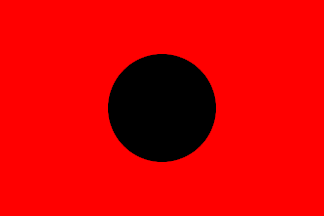
Egypt uses an elaborate warning system: comprising only one flag:
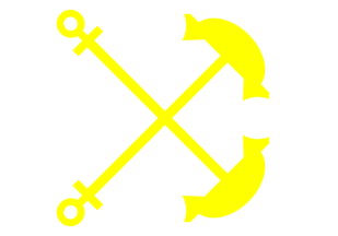 image by Eugene Ipavec, 8 November 2007
50a (white, two yellow anchors, crossed, the stocks turned towards the hoist):
“Too much sea, pilot can not go out”. Attached as < eg_vsws50a.gif> .
Jan Mertens, 7 November 2007
Fiji uses one signal, which is a flag:
 image by Eugene Ipavec, 21 December 2007
35a: yellow pennant meaning “Storm/hurricane alert. A tropical cyclone of storm
or hurricane intensity exists and may affect the locality within 24 or 36
hours.”
Jan Mertens, 8 November 2007
France uses the international system.
Jan Mertens, 8 November 2007
French Polynesia uses the international system.
Jan Mertens, 8 November 2007
Gabon uses the international system.
Jan Mertens, 8 November 2007
Gambia uses the international system.
Jan Mertens, 8 November 2007
Ghana uses a single signal, which is not a flag. Jan Mertens, 8 November 2007
Gibraltar uses a few signals none of which is a flag. Jan Mertens, 8 November 2007
Grenada uses a signal flag set closely resembling US use:
|
|
|
| image by António Martins-Tuválkin |
41a (double set of red pierced black): "Winds above 63 kt".
image by António Martins-Tuválkin
40a (red pierced black): "Winds 34-63 kt".
![[information flag]](../images/w/weat-red.gif) image by António Martins-Tuválkin
image by António Martins-Tuválkin
56a (red pennant): "Winds 28-33 kt"
Jan Mertens, 9 November 2007
India uses an elaborate signalling system, but no flag(s).
Jan Mertens, 16 November 2007
Israel uses a few signals, but there is no flag among them.
Jan Mertens, 16 November 2007
Italy uses a few signals, but there is no flag among them.
Jan Mertens, 16 November 2007
South Korea does not use visual warning signals at present. Instead, radio is used.
Jan Mertens, 23 March 2008
Madagascar uses the international system.
Jan Mertens, 10 February 2008
Malaysia uses "For national coastal waters, visual strong wind and rough sea warnings at Kuala Trengganu and Tumpat. Notice board display of information on strong wind and rough sea at Mersing and various fisheries departments in Pahang."
It is not said how these visual warnings look like.
Jan Mertens, 10 February 2008
Malta uses a number of signals but there is no flag among them.
Jan Mertens, 24 February 2008
Mozambique adheres to the international system – 6a is a single black rectangular flag,
7a two black rectangular flags above each other.
Jan Mertens, 2 March 2008
Mauritania uses the international system.
Jan Mertens, 24 February 2008
Myanmar uses an extensive number of signals but there is no flag among them. Jan Mertens, 9 March 2008
The Netherlands follow the international specification. Also: "Night signals are displayed at Flushing, Hook of Holland,
IJmuiden, Den Helder and Terschelling. Day signals are not displayed."
Jan Mertens, 9 March 2008
The Netherlands Antilles use the well-known US signal set but with local differences.
| 40a (red pierced black): "Gale warning: winds 39 miles an hour (34 kt) and upwards. |
|
| 56a. Small craft warning: winds and seas or sea conditions are only dangerous to small craft operations. Winds range up to 38 miles an hour (33 kt) |
|
|
| 39a. Gale warning: winds within the range 39-54 miles an hour (34-47 kt). |
|
|
| 40a. Whole gale warning: winds within the range 55 to 73 miles an hour (48 to 63 kt) |
|
|
| 41a. Hurricane warning: winds 74 miles an hour (64 kt) and upwards. |
|
Jan Mertens, 16 March 2008
Nigeria adheres to the international system.
Jan Mertens, 9 March 2008
Norway uses a number of signals but there is no flag among them.
Jan Mertens, 9 March 2008
Portugal uses an extensive number of signals among which there are two flags (of the international system):
7a (set of two black flags, one above the other): "Wind expected to back (counter-clockwise change in direction).
6a (black flag): "Wind expected to veer (clockwise change in direction).
Jan Mertens, 16 March 2008
Pakistan uses an extensive number of signals but there is no flag among them.
Jan Mertens, 9 March 2008
The Philippines uses the international system.
Jan Mertens, 9 March 2008
St Kitts and Nevis use a subset of the US signals.
| 56a (red pennant): "Winds 28-33 kt." |
|
|
| 40a (red pierced black): "Winds 34-63 kt." |
|
|
| 41a (double set of red pierced black): "Winds above 63 kt." |
|
Jan Mertens, 23 March 2008
Samoa uses one signal which is a flag
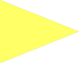 image by Eugene Ipavec, 21 December 2007
35a: yellow pennant meaning “Storm/hurricane alert. A tropical cyclone of storm
or hurricane intensity exists and may affect the locality within 24 or 36
hours.
Jan Mertens, 30 March 2008
|
Fair Weather
|
Rain or Snow
|
Information
|
|
Local Rain or Snow
|
Cold Wave
|
Temperature Change
|
There is an interesting set of signal flags that are (were) used as weather signals by the US Department of Agriculture. Perhaps these went out of use with the widespread use of radio in the early years of this century (or maybe they are still used? This is what "The World Almanac" (1893) had to say (my comments in square brackets):
"The weather bureau furnishes, when practicable, for the benefit of the general public and those interests dependent to a greater or less extent upon weather conditions, the 'forecasts' which are prepared at that office daily at 10am and 10pm, for the following day. These weather forecasts are telegraphed to observers at stations of the weather bureau, railway officials, and many others, and are so worded as to be readily communicated to the public by means of flags or steam whistles. The flags adopted for this purpose are five in number, and of the form and dimensions indicated below:
1. White flag, six feet square [1800mm], indicates clear or fair weather.
2. Blue flag, six feet square, indicates rain or snow.
3. White and blue flag (parallel bars of white and blue)*, six feet
square, indicates that local rains or showers will occur, and that the
rainfall will not be general
*an accompanying picture indicates a horizontal bicolour, white over blue
4. Black triangular flag four feet at the base [presumably hoist; 1200mm] and six feet in length, always refers to temperature.
When placed above [previously mentioned flags] number 1, 2, or 3 it indicates warmer weather; when placed below numbers 1, 2, or 3 it indicates colder weather; when not displayed, the indications are that the temperature will remain stationary, or that the change in temperature will not vary more than four degrees [Fahrenheit] from the temperature of the same hour of the previous day from March to October inclusive, and not more than six degrees for the remaining months of the year.
| Fair Weather | Rain/Snow | Local Rain/Snow | ||||
|---|---|---|---|---|---|---|
| No major change from previous day |
|
|
|
|||
| Rising Temperature |
|
|
|
|||
| Falling Temperature |
|
|
|
|||
| 5. White flag, six feet square, with black square in centre [picture suggests two feet/600mm square], indicates the approach of a sudden and decided fall in temperature. This flag is not to be displayed unless it is expected that the temperature will fall to forty-two degrees or lower, and is usually ordered at least twenty-four hours in advance of the cold wave. When number five is displayed, number four is omitted, but it may be displayed above either flag 1 or 2. | Cold Front Signals [click on flag for larger image] |
||||
| Cold Front Precipitation |
Cold Front Fair Weather |
||||
|
|
|
||||
A special Storm flag, red with black square in the centre, is prescribed for use in North and South Dakota, Minnesota (except at lake stations), Iowa, Nebraska, and Wyoming, to indicate high winds, accompanied by snow, with temperature below freezing.
When displayed on poles, the signals should be arranged to read downward;
when displayed from horizontal supports, a small streamer [colour unspecified]
should be attached to indicate the point from which the signals are to be
read."
James Dignan, 06 December 1997
| Northwest winds |
|
|
| Northeast winds |
| |
| Southwest winds |
|
|
| Southwest winds |
|
These flags are depicted in "Signal flags used at Weather Bureau Display Stations" In: The Aims and Methods of Meteorological Work by Cleveland Abbe. In: Maryland Weather Service, Johns Hopkins Press, Baltimore, 1899. Vol I. Page 296.
Red pennant above square red flag pierced black: captioned "N.E. WINDS".
Square red flag pierced black above red pennant: captioned "S.E. WINDS".
White pennant above square red flag pierced black: captioned "N.W. WINDS".
Square red flag pierced black above white pennant: captioned "S.W. WINDS".
WIND SIGNAL. Pennants with the Storm Signal indicate the direction of the wind; red, easterly. from northeast to south; white, westerly, from southwest to north. The Pennant above the flag indicates that the wind is expected to blow from the northerly quadrants; below, from the southerly quadrants.
Jan Mertens, 7 November 2005
| Small Craft Warning |
|
|
| Gale Warning |
|
|
| Storm/Full Gale Warning |
|
|
| Hurricane Warning |
|
From navytimes.com:
Coasties revive foul-weather warning flags
By Patricia Kime - Staff writer
Posted : Wednesday May 30, 2007 18:19:14 EDTDouble red-and-black storm-warning flags once heralded an impending hurricane, urging mariners to take cover and seaside residents to flee.
The flags disappeared from common use in 1989, when the National Weather Service discontinued the program.
This summer, the Coast Guard officially is bringing them back.
Starting June 1, select Coast Guard stations will hoist storm flags in foul weather: red triangle for small craft warning; double red triangle for gale warning; single red-and-black square for storm warning; and the feared double flags for hurricane warning.
“[This is] a Coast Guard initiative to reinforce the Coast Guard’s role as lifesavers, reaffirm to local communities the Coast Guard’s role as experts concerning local boating matters and visually communicate ... the lesson of Hurricane Katrina to take personal responsibility for individual safety,” said Rear Adm. David Pekoske in an announcement May 30.
Some marinas and stations voluntarily have carried on the tradition of hoisting such flags, but participation was spotty.
The Coast Guard hopes that residents in storm-prone areas will see the flags and listen to National Oceanographic and Atmospherics Administration radio broadcasts for further details, officials say.
According to NOAA, more than half the country’s population lives along the coasts. In 2003, roughly 153 million people lived in 673 coastal counties.
David C. Fowler, 31 May 2007
![[fair weather flag]](../images/w/weat-fr.gif)
![[rain or snow flag]](../images/w/weat-rs.gif)
![[local rain or snow flag]](../images/w/weat-lrs.gif)
![[cold wave flag]](../images/w/weat-cld.gif)
![[temperature change flag]](../images/w/weat-tmp.gif)
![[information flag]](../images/w/weat-wtr.gif)