
Last modified: 2009-07-26 by dov gutterman
Keywords: ecuador | tungurahua | sierra |
Links: FOTW homepage |
search |
disclaimer and copyright |
write us |
mirrors

image by Jaume Olle', 8 September 1996
See also:
Cantons:
Other sites:
Tungurahua is a province in central Ecuador in Sierra region.
The capital is Ambato.
Željko Heimer, 15 July 1996
From provincial
website:
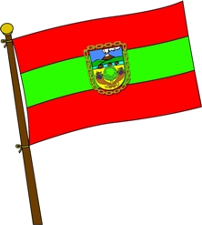
"Consta de tres franjas iguales y horizontales: la del
centro es de color verde y las esteriores rojas.
El rojo significa la rebeldía se sus hombres y el verde la
felicidad y el color de sus campos.
La Bandera que utilizan las entidades oficiales de la provincia
debe llevar en la franja central, el Escuda de la
Provincial."
Falko Schmidt, 12 January 2005
Version of the Tungurahua provincial flag with coat of arms on it
is for official use as seen at Ambato
municipal website.
Valentin Poposki, 1 May 2008
The province was founded on 3 July 1860. It is named after
theTungaruha (5,023 m asl), an active stratovolcano that woke up
in 1999. The last significant eruptions occurred in August 2006
and February 2008.
From the provincial
website: "The flag is made of three equal horizontal
stripes, the central stripes being green and the the two other
red. Red means obstination of the inhabitants and green means
happiness and the colour of the fields. The flag used by the
official bodies should bear in the middle stripe the provincial
coat of arms".
The coat of arms is presented on the provincial
website as follows: "The coat of arms was desgined par
Juan José Boniche y Luna in 1794. Made of an ellipse surrounded
by a chain, the coat of arms is divided into three quarters. The
first quarter represents volcano Tungurahua in eruption. The
volcan is ultramarine blue, the gases it releases are dark coffee
colour and the the cordilera is green. This symbol recalls that
the province was named after the volcano, which is still active.
The central quarter shows a river from which emerge three grey
stones representing the ford on river Topo.
The lower quarter, on a green field, shows a cinammon flanked by
two cornucopiae filled with fruits, representing the resources of
the province; the cornucopiae are crossed below the tree and
charged with a key recalling that the region, once called
"Cinammon Region", is the entrance gate to
Amazonia."
This description must match an older version of the coat of arms,
which is no longer elliptical. There is a problem with the
colours, but there are two reported versions of the coat of arms:
- on the provincial
website (small image), with the colours more or less matching
the description - especially the colour of the lower field,
green;
- on the Ambato
municipal website with different colours - especially the
colour of the lower field, yellow.
The flag, without the arms, is shown on a photograph
taken in the Family Provincial Park, dated 30 September 2008.
Ivan Sache, 31 October 2008
1)![[Flag of Tungurahua]](../images/e/ec-t1.gif)
image by Željko Heimer, 15 July 1996
Flag according to W.Smith (insecure)
2)![[Flag of Tungurahua]](../images/e/ec-t2.gif)
image by Jaume Olle (reported by author, no source)
The middle stripe is in fact green.
Jaume Olle, 8 September 1996
t.jpg)
image from Ambato
municipal website